
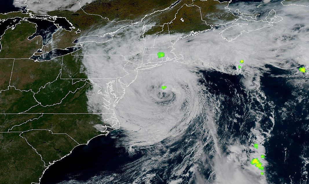
An updated Saturday forecast brings stronger winds, thunderstorms and repeated rounds of rain through Sunday, while coastal flooding could make roads impassable in parts of Ocean and Burlington counties.
NEW JERSEY — The weekend weather outlook has taken a turn for the worse across New Jersey, with forecasters now calling for nearly continuous rain, thunderstorms, damaging wind gusts and significant coastal flooding through Sunday.
The updated forecast calls for a 90% chance of rain Saturday afternoon, Saturday night and again Sunday, while winds across parts of the Jersey Shore could gust to 50 mph.
[wpdevart_facebook_comment curent_url=”http://yourdomain.com/page-url” title_text=”Facebook Comment” order_type=”social” title_text_color=”#000000″ title_text_font_size=”22″ title_text_font_famely=”monospace” title_text_position=”left” width=”100%” bg_color=”#d4d4d4″ animation_effect=”random” count_of_comments=”2″ ]
Along the immediate coast, conditions are even more severe. National Weather Service forecasts for Coastal Ocean and Eastern Monmouth counties show separate High Wind Warnings, with gusts potentially reaching 60 mph in exposed coastal communities.
Winds strengthen Saturday afternoon
Showers will continue through Saturday afternoon, with thunderstorms possible after 5 p.m.
Temperatures will struggle to reach 61 degrees as north winds run around 20 mph. Gusts could reach 45 mph.
The chance of rain is 90%, with another tenth to quarter-inch possible during the afternoon. Thunderstorms could produce locally higher amounts.
A Wind Advisory remains in effect through noon Sunday for Ocean, western Monmouth, Atlantic, Cape May and southeastern Burlington counties.
The National Weather Service said north winds of 10 to 20 mph could produce gusts as high as 50 mph.
Those winds could blow around unsecured outdoor objects, bring down tree limbs and cause scattered power outages. Drivers of trucks, vans, buses and other high-profile vehicles could also have difficulty on exposed roads and bridges.
Rain intensifies overnight
The weather is not expected to settle down after sunset.
Showers and possibly a thunderstorm will continue before midnight, followed by more rain overnight and another chance of thunderstorms after 2 a.m.
The chance of precipitation remains at 90%.
Between a half-inch and three-quarters of an inch of additional rain could fall overnight.
Temperatures will drop to around 53 degrees while north winds remain near 20 mph, with gusts reaching approximately 40 mph.
Forecasters said there could be a temporary lull in the wind Saturday evening before conditions strengthen again overnight and into Sunday morning.
Sunday now looks like a washout
Sunday has deteriorated into the wettest portion of the weekend forecast.
Showers and thunderstorms are expected throughout the day with a 90% chance of precipitation.
Another three-quarters of an inch to one inch of rain could fall.
The high will reach only around 65 degrees as northeast winds remain around 20 mph. Gusts could reach 35 mph even after the strongest overnight winds begin easing.
Anyone with outdoor plans Sunday should prepare for rain rather than expecting brief passing showers.
Coastal flooding becoming a major concern
The storm is also pushing water into the back bays and tidal waterways along the Jersey Shore.
A Coastal Flood Warning remains in effect for Ocean and southeastern Burlington counties until 2 p.m. Sunday.
Forecasters expect one to two feet of inundation above ground level in low-lying areas near shorelines and tidal waterways.
At those levels, widespread roadway flooding is expected in coastal and bayside communities. Some roads could become impassable, and vulnerable structures may begin experiencing damage.
Barnegat Bay at Barnegat Light is forecast to reach moderate flood stage during the Saturday evening high tide, with another moderate flooding cycle expected Sunday morning.
The National Weather Service is warning motorists not to attempt to drive through flooded roads.
Shore communities face rough surf as well
The immediate coastline faces additional hazards beyond wind and tidal flooding.
Coastal Ocean County remains under a High Surf Advisory and a high risk for rip currents through Sunday evening. The National Weather Service said large breaking waves could reach roughly 10 to 11 feet in the surf zone.
That combination of persistent onshore winds, rough surf and elevated water levels increases the possibility of beach erosion and flooding around barrier-island communities.
Residents in flood-prone areas of Ocean County should pay particular attention to the evening and Sunday morning high-tide cycles.
Rain continues Sunday night
Conditions will remain unsettled Sunday night, although winds should begin decreasing.
Showers are expected mainly before 2 a.m., with an 80% chance of rain.
Another quarter-inch to half-inch could fall before the storm begins pulling away.
Temperatures will remain relatively mild around 57 degrees, with northeast winds between 5 and 15 mph and gusts up to 25 mph.
Improvement finally arrives Monday
Monday will still begin cloudy and damp.
There is a 50% chance of showers, mainly before 2 p.m., with a high around 67 degrees.
Winds will become much lighter from the northwest at around 5 mph.
The most significant weather impacts should therefore run from Saturday afternoon through Sunday night, with the greatest concerns being strong wind, repeated heavy rain and coastal flooding.
For portions of the Jersey Shore, Sunday morning could prove to be the most difficult period as high tide, strong northeast winds and ongoing rainfall overlap.