

New Jersey faces several days of below-normal-feeling temperatures, persistent clouds, gusty northeast winds and increasing rain chances heading into the weekend.
NEW JERSEY — Sunshine will be hard to come by across New Jersey through the weekend as a stubborn stretch of cool, cloudy and increasingly wet weather settles over the state.
Temperatures will struggle to get much beyond the upper 60s for much of the period, while persistent northeast winds will make it feel even cooler. Rain chances increase heading into Friday and the weekend, keeping outdoor plans questionable through Sunday.
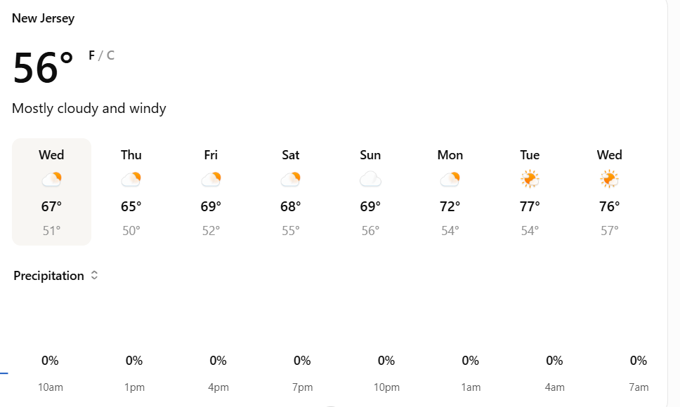
Cloudy, breezy Wednesday starts the stretch
Wednesday will remain mostly cloudy with temperatures reaching only around 68 degrees.
Northeast winds of 20 to 25 mph will add a noticeable chill, particularly along the Jersey Shore and in exposed areas. Wednesday night stays mostly cloudy as temperatures fall into the low 50s, with winds remaining brisk at 15 to 20 mph.
The pattern will feel considerably different from the warmer conditions New Jersey typically sees earlier in September.
Readers can follow continuing New Jersey weather coverage throughout the week as conditions change.
Thursday offers little improvement
Thursday brings a few breaks in the clouds, but temperatures remain cool.
The forecast calls for partly sunny skies and a high near 66 degrees, with northeast winds around 20 mph. Thursday night turns mostly cloudy again as temperatures dip to around 52.
The persistent northeast flow will continue to keep coastal communities particularly breezy.
The National Weather Service advises residents to follow updated local forecasts because wind speeds and rain timing will vary across different parts of New Jersey.
Rain chances return Friday
The wetter part of the forecast begins Friday.
Showers become possible under mostly cloudy skies, with highs again hovering around 66 degrees. North winds around 20 mph could gust as high as 30 mph.
Rain chances are around 30% during the day and increase to around 40% Friday night. Some areas could pick up measurable rainfall as showers develop.
The combination of clouds, wind and damp conditions will make Friday feel more like mid-autumn than late September.
Saturday could be the wettest day
Saturday currently carries the highest rain chances of the stretch.
Showers are likely, particularly during the afternoon, with the probability of rain around 60%. Temperatures remain stuck in the mid-60s despite occasional breaks in the clouds.
Showers remain likely Saturday evening before gradually becoming more scattered overnight.
Anyone planning outdoor festivals, youth sports, beach trips or other weekend activities should keep an eye on updated forecasts as the timing becomes clearer.
The New Jersey Office of Emergency Management also provides statewide weather and preparedness information when storms or hazardous conditions threaten the region.
Sunday remains unsettled
The weekend does not completely dry out Sunday.
Mostly cloudy skies are expected with a chance of showers and highs near 67 degrees. Rain chances remain around 50%, while Sunday night should stay mostly cloudy with lows in the mid-50s.
The extended stretch means New Jersey could go several days without a truly sunny afternoon.
Cooler weather dominates through the weekend
The biggest theme through Sunday will be consistency: clouds, northeast winds, temperatures in the 60s and intermittent rain.
Conditions will vary somewhat from North Jersey to the Shore and South Jersey, particularly with rainfall timing and wind strength, but much of the state will remain cooler and cloudier than residents have grown accustomed to in recent weeks.
Follow Shore News Network coverage of New Jersey, Weather, Jersey Shore, Local News and State News for updated conditions.